![]() Grand Canyon East (Escalante Route) - Thumbnails
Grand Canyon East (Escalante Route) - Thumbnails
![]()
![]() Grand Canyon East (Escalante Route) - Thumbnails
Grand Canyon East (Escalante Route) - Thumbnails
![]()
These are pictures of the third of three solo backpack hikes that I did in May-June 2003 (this hike took four days -- and I saw no other hikers until halfway through the last day):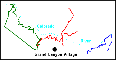
If you are interested in hiking the Escalante Route (pictures 6 to 40 below), I have some information at the bottom of the page that you might find useful. This was my 13th hiking trip to the Grand Canyon, which is probably my favorite hiking destination. Since I took a lot of pictures of the corridor trails (Bright Angel and Kaibab) last year, I focused on other trails this time. Click a little picture to enlarge it. To see all the pictures in sequence, click the first picture (or here) and then just keep clicking the right-arrow for the next picture.
- GREEN: Go down the Hermit a little, up the Waldron, west on the closed Old Pasture Road, down the Bass to the river, east on the Tonto across the "jewels" canyons, and return on the Hermit.
- RED: Go down the Hermit to the Tonto, east on the Tonto to Cremation, down the Kaibab to the river, east on the Clear Creek trail to the creek and then back, north on the Kaibab to the North Kaibab Trailhead, back to the river, and return on the South Kaibab.
- BLUE: Take the Tanner down to the river, west on the Escalante Route to Red Canyon, west on the Tonto to Horseshoe Mesa, and return on the Grandview.


Click here for automated slide show.
For good directions on how to follow the route, see here and here; the first of these includes the directions that the national park gives you.Most of the trail is relatively easy. However, I found four places to be scary and challenging, but doable:
I recommend gloves for these (I used cheap cotton work gloves), since they protect your hands and give you a better grip. It would be helpful to have a hiking partner (I went solo). Also, since these four tricky places are tiring and close together and time consuming, I suggest that you not plan to cover a huge number of additional miles on the day you do them.
- The two dryfalls in 75-mile Creek that you have to climb down (pictures 30 to 32). In both cases, I lowered my pack by a rope and then climbed down slowly and carefully. The first falls is higher but has better hand- and foot-holds; the second is lower but with fewer holds. As with most dryfalls, the stone is smooth and slippery.
- The Papago Wall (pictures 37 and 38) that you must climb up. The cliff is about 50-foot high and vertical, but there are hand- and foot-holds; the main challenge is to get over your fear of falling. I didn't use rope for the Papago Wall or Slide.
- The Papago Slide (picture 39 shows a small part of it) that you must go down. This is a steep pile of dirt, small talus rocks, and larger bolders -- and goes on for a long distance. I went down in a sitting position, grabbing onto things with my hands and feet.
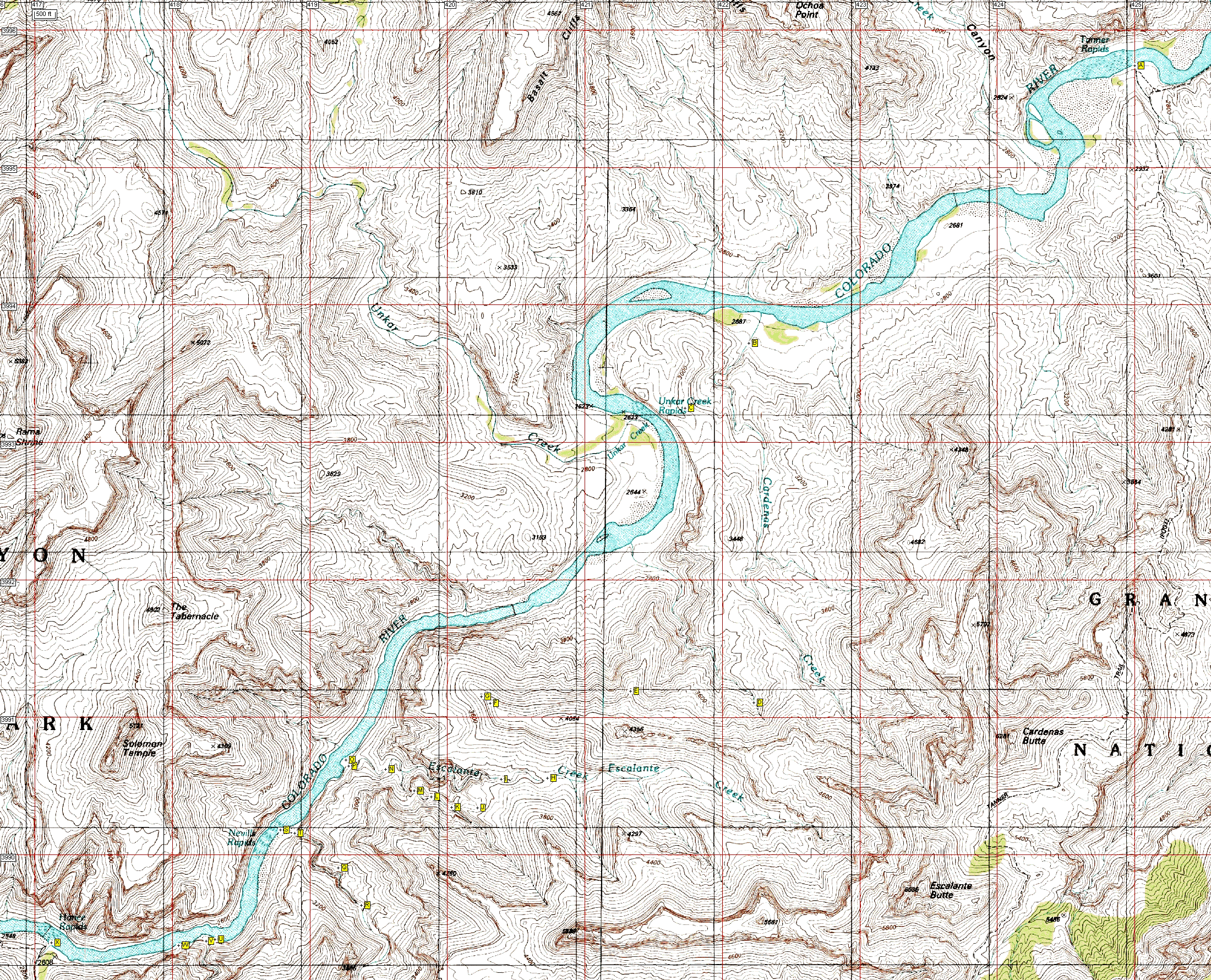
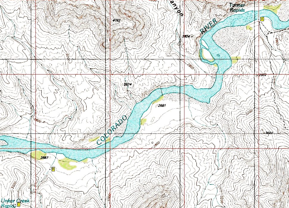
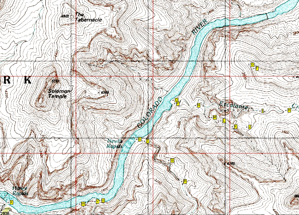
I used my Garmin Etrex GPS to create waypoints for the route, included here in twp downloadable versions: GPS Exchange GPX (rename from "escalante.txt" to "escalante.gpx" and use with the ExpertGPS or EasyGPS or other programs) and Comma Delimited Text File CSV. I also include a big topo map showing the waypoints; if you prefer smaller maps, use individual ones that cover waypoints A-C, C-G, and F-X. All of these use the WGS 84 datum and the maps use UTM coordinates (so the red lines are one kilometer apart). GPS waypoints are usually accurate to 100 feet or less; elevations can be much less accurate. My GPS waypoints are lettered "A" through "X," which you follow in order:
- Mouth of Tanner Creek (picture 6)
- Cross Cardenas Creek
- Turn south and climb
- Cross unnamed drainage (picture 12)
- Middle of contour (at the north spur) (picture 14)
- Reach west end of contour (picture 16)
- Descend to here before turning east (picture 17)
- Reach Escalante Creek -- head downstream (don't follow cairns on the other side) (pictures 18 and 19)
- Leave Escalante Creek, following cairns to the left
- Enter into small drainage
- Enter into bigger drainage
- Continue
- Continue
- Continue
- Reach mouth of Escalante Creek (pictures 23 to 25)
- Follow trail out of the drainage (picture 27)
- Don't enter 75-mile Creek here
- Go down two dryfalls into 75-mile Creek (pictures 30 to 32)
- Reach mouth of 75-mile Creek (picture 34)
- Follow trail out of drainage (picture 35)
- Reach mouth of Papago Creek (picture 36)
- Climb Papago Wall to get out of drainage (pictures 37 and 38)
- Go down Papago Slide (carefully) (picture 39)
- Red Canyon (Hance Rapids) - End of Escalante Route (picture 40)